
Hiking Trails on Mammoth Mountain
Explore the mountain by foot
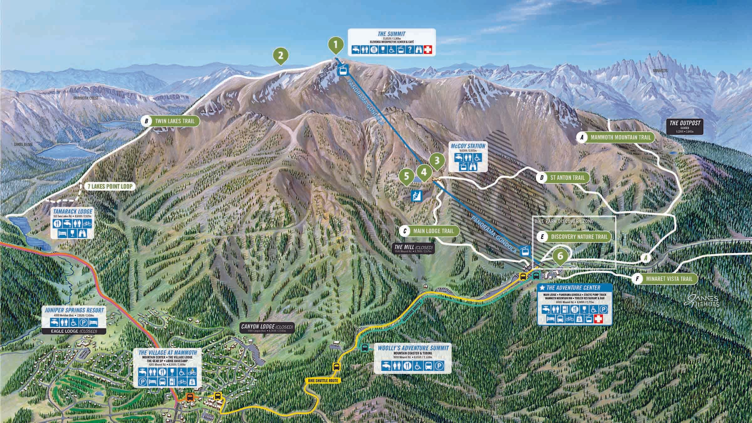
No matter your ability, you can find a rewarding and scenic hike on Mammoth Mountain. Make it a big adventure with a round-trip hike, or take in the views with a Scenic Gondola Ride uphill (ticket required) to either the top or mid-station, followed by a downhill journey on foot.
Hiking Trails
| Mammoth mountain trail | OPEN 5 miles one-way, strenuous, 3 hours | From the wide multi-use trail behind and to the left of the Eleven53 Interpretive Center, the Mammoth Mountain trail winds down the back of the mountain, with views of the San Joaquin river valley below and surrounding peaks before heading back to the Main Lodge via Red's Lake. |
| the Dragon's Back/TWIN LAKES Trail | OPEN 3 miles one-way, strenuous, 3 hours | Descend Mammoth Mountain’s summit to the scenic Lakes Basin. Meander down into the forest past the “Bottomless Pit,” a natural arch that drops toward Twin Lakes. Be sure to look for the Dragon's Back/Twin Lakes sign where the hiking trail breaks from the Skid Marks bike trail. Then take the free shuttle from Tamarack Lodge (at Twin Lakes) to The Village. |
| main lodge trail from mccoy station | OPEN 2 miles one-way, moderate,1 hour | Enjoy wide-open views on an easy descent from McCoy Station, the mid-mountain gondola stop, to Main Lodge. Before starting on the trail, stop for lunch at the nearby picnic area – just ask the gondola operator for directions when you get off at McCoy Station. |
| st Anton trail from McCoy Station | CLOSED 3 miles one-way, moderate, 2 hours | High-alpine terrain gives way to thick pine forest as you snake your way from mid-mountain at McCoy Station down to the Adventure Center. |
| discovery nature trail | OPEN 1 mile round-trip, moderate, 1 hour | Start this loop next to the Mammoth Ski & Snowboard Team headquarters, the brown and red building across the road from the Adventure Center. Learn about the resilient flora and fauna that call Mammoth home, identify local critters, birds, and trees and discover how they’ve adapted to their high altitude environment along the route. |
| MINARET VISTA TRAIL | OPEN 3 miles round-trip, moderate, 2 hours | The trail starts behind the Mammoth Mountain Inn, gradually gaining altitude through a lovely mixed conifer forest and then flattening out to an open, pumice-covered ridge. At the vista, hikers are rewarded with a sweeping view of the Minarets, Ritter Range and the river valley below. |
| STARKWEATHER TRAIL FROM MINARET SUMMIT | OPEN 2.5 miles one-way (return via shuttle), moderate, 1–2 hours | Look for the trail across the road from the Minaret Summit ranger booth. This pleasant hike switchbacks down to the road across from Starkweather. From there, you can hop on the shuttle (fee required) to go check out Devils Postpile and Rainbow Falls, or ride it back to the ranger booth. |
More Trails Around Mammoth Lakes
There are many places to explore around Mammoth Lakes and the Eastern Sierra. Visit MammothTrails.org or VisitMammoth.com to learn more about popular destinations you can reach on foot.
Hiking trails may be impacted by weather, snow, or other conditions common in mountain environments. Please be prepared for all conditions and learn about high-altitude safety prior to hiking. Our on-site mountain hosts are available to answer questions about trail conditions.